 NERC Data Catalogue Service
ESRI grid
Type of resources
Topics
Keywords
Contact for the resource
Provided by
Years
Formats
Representation types
Update frequencies
Scale
-
The BGS Debris Flow Susceptibility Model for Great Britain v6.1 is a 1:50 000 scale raster dataset of Great Britain providing 50 m ground resolution information on the potential of the ground, at a given location, to form a debris flow. It is based on a combination of geological, hydrogeological and geomorphological data inputs and is primarily concerned with potential ground stability related to natural (rather than man-made) geological conditions and slopes. The dataset is designed for those interested specifically in debris flow susceptibility at a regional or national planning scale such as those involved in construction or maintenance of infrastructure networks (road or rail or utilities), or other asset managers such as for property (including developers and home owners), loss adjusters, surveyors or local government. The dataset builds on research BGS has conducted over the past 15 years investigating debris flows. The model was designed to identify potential source-areas for debris flows rather than locate where material may be deposited following a long-run-out failure i.e. the track and flow of debris. This work focuses on natural geological and geomorphological controls that are likely to influence the initiation of debris flows. It therefore, does not consider the influence of land use or land cover factors.
-
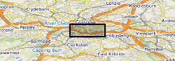
The UK Geoenergy Observatories (UKGEOS) Glasgow superficial deposits GSI3D model outputs, created by the British Geological Survey, provide a semi-regional overview of the depth, thickness and extent of glacial and post-glacial lithostratigraphic units above rockhead. The model allows users to visualise the likely subsurface sequence to be found beneath this part of Glasgow, applicable at a scale of around 1: 25,000 to 1: 10,000. The data is supplied as grids and shapefiles over a 7 by 4.15 km area, with the depth range to around 40 m below Ordnance Datum. This model describes an interpretation of the shallow geology before the UKGEOS Glasgow boreholes have been drilled, and was used to inform the expected sequence on drilling. Further details and model limitations can be found in the accompanying metadata report http://nora.nerc.ac.uk/id/eprint/524556
-
Geological model comprising artificial ground and superficial deposits in the city of Cardiff. Undifferentiated bedrock is included beneath the superficial deposits. This model provides a geological framework model and calculated surfaces for the superficial deposits for the city of Cardiff, principally Till, Glaciofluvial deposits, Alluvium and Tidal Flat Deposits.